


Analyze the data and learn more about the city

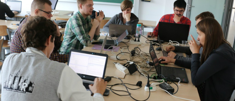
Participants of the Hakaton analyzed city data, photo from Przemysław Biecek's blog
What can you do with data taken from official announcements, information about movement of public transport vehicles, data from mobile networks or cameras? This is what preoccupies members of the VaVeL project, financed from the EU program Horizon 2020. The Faculty of Mathematics and Information Science (MiNI) of the Warsaw University of Technology is one of the partners of the project.
“The goal of the project is to extend the possibilities of using urban data to make life easier for the citizens,” says Prof. Przemysław Biecek, Ph.D. Eng., from the MiNI Faculty of the Warsaw University of Technology. “To reach this goal, we are building infrastructure to collect and use urban data. All sorts of data. By monitoring it we are able to suggest interesting and useful conclusions and ideas to the authorities and citizens.”
There are 10 entities involved in the project, including three from Poland. Apart from the MiNI Faculty they are Orange Polska and the Capital City of Warsaw. “VaVeL is divided into several packages,” Przemysław Biecek explains. “One of the tasks that researchers from our University are working on together with Orange and the City of Warsaw is a smart planner – we want to plan traffic in the city using information about what is currently going on.”
Test during a hackathon
Researchers from the Warsaw University of Technology have been working on this project with city officials and Orange for 2 years. Over this time, they have developed a platform which aggregates, cleans, collects and provides access to data. “We wanted to see new ways of using the platform,” Przemysław Biecek says. “We thought a hackathon would be a great way to do this.”
Hackathon is a kind of workshop during which analytical and IT projects are developed and implemented. It is also a great place to meet new people working in a given field and an opportunity to implement a solution in a specific space and time.
The participants of the Urban Sensors hackathon and researchers from the Warsaw University of Technology, representatives of Orange and Warsaw authorities met at the MiNI Faculty at the end of September. The participants were given access to three sources of data: online (i.e. real-time) and offline (i.e. historical) data about the position of buses and trams in Warsaw and offline data from the mobile phone network.
“We had experienced developers and analysts among the participants, but there were some beginners, too,” Przemysław Biecek recalls. “Some of them worked individually, others in teams, including from large companies such as Pearson or GfK Polonia.”
Hakaton took place on September 26, 2017, photo from Przemysław Biecek's blog
How to make moving around Warsaw easier?
The whole-day event ended with a presentation of the developed solutions. The idea proposed by the Pearson team proved to be most popular. “It is an application called CzyZdążę.pl (meaning “Will I make it?” in Polish), which shows the location of the nearest bus or tram that can take us to our destination and indicates the average time of travel,” Przemysław Biecek says.
The researcher also mentions two other very interesting solutions developed by hackathon participants. “Ewa Baranowska, who is preparing to defend her Master’s thesis at our Faculty, designed a map that shows the current location of buses and trams in the vicinity and their delays in relation to the timetable,” Przemysław Biecek says. “Jan Bajerski, an IBM employee with a passion for analyzing transport data, compared the actual and expected travel times of buses and trams. He used Marey diagrams to show how a vehicle of a given line should follow its route according to the timetable and how long it actually takes to do it.”
Based on this analysis, we can see on what stretches and at what times delays occur, or, more specifically, where and when traffic jams are formed in Warsaw. This knowledge can be very useful for the inhabitants and authorities of the Polish capital.
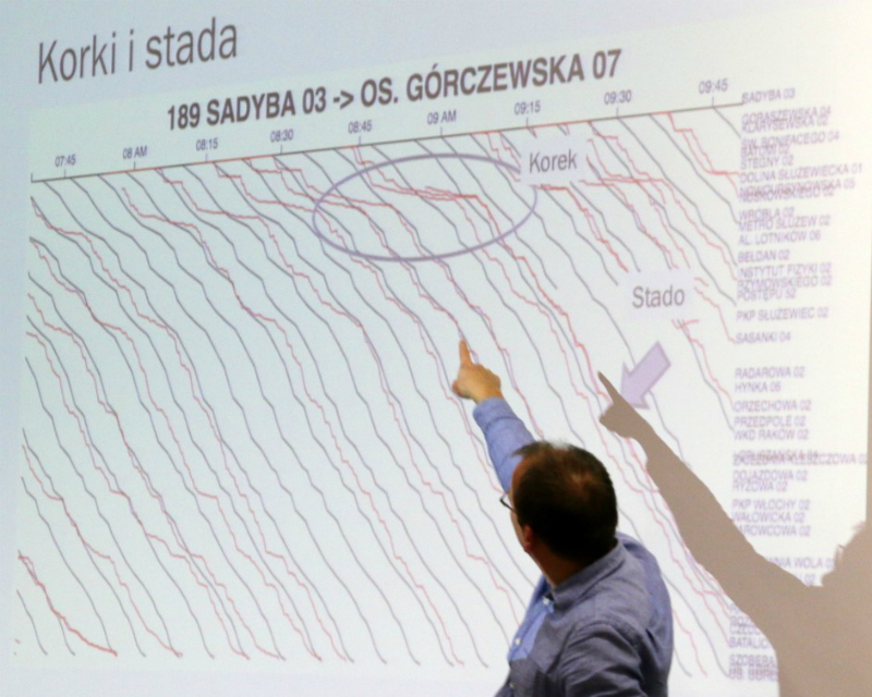
Jan Bajerski used the diagrams Mareya, photo from Przemysław Biecek's blog
Warsaw University of Technology – a meeting place
“Building the platform was the first part of the task, the second – more important – is to put it in use,” Przemysław Biecek points out. “The greatest challenge is often to match the right data with people who have the right skills and ideas how to use it. The opportunity to discuss new ideas with people working with urban data on an everyday basis cannot be overestimated, either. This is what we managed to do at our hackathon. This way we show that the Warsaw University of Technology is not just a place where we teach students how to analyze data, but also a place where interesting research is carried out, a place where people can come, meet and work together.”
Will we soon be using the solutions proposed during the event organized at the Faculty of Mathematics and Information Science? “The ideas have a commercialization potential, but I do not want to speak on behalf of the authors,” Przemysław Biecek concludes.
***
Read more about the VaVeL project on www.vavel-project.eu. On behalf of the Warsaw University of Technology, the project is coordinated by Marcin Luckner, Ph.D. Eng., Director of the Business Research Center.
Agnieszka Kapela
Promotion and Information Office
© 1998-2026 Warsaw University of Technology
Pl. Politechniki 1, 00-661 Warsaw, Poland
