


Flying a Drone to an Accident – the View is Better from Above
Nowadays, you can buy a drone in any supermarket. For some it’s just another gadget, for others – a tool for work and a platform for obtaining interesting and important data. Specialists from the Faculty of Geodesy and Cartography of the Warsaw University of Technology know how to use drones to document traffic accidents.
When a traffic accident or collision takes place, the Police have to, among other things, secure the site and prepare appropriate technical documentation. In such situations, accuracy and specificity of measurements are not the only important elements. Time is also crucial. Everyone is interested in restoring traffic, removing danger and reducing traffic jams as quickly as possible. Our specialists help with that. They use drones and photogrammetry to help the Police in their surveys.
Young and Capable
The subject was initiated in the engineer’s thesis (which took 3rd place in the nationwide geodesy and cartography thesis competition) of Konrad Sosnowicz, Eng., a student at the Faculty of Geodesy and Cartography of the Warsaw University of Technology and a member of the Geodesy and Cartography Student Association “GEOIDA”. He intended to use low-altitude photos to survey traffic events. The idea hit the mark because SkySnap and Infomatico soon took interest in cooperation with the Department of Photogrammetry, Remote Sensing and Geographic Information Systems of the Faculty of Geodesy and Cartography. Thus, our geodesy students execute the project co-financed by the EU and named “Preparation of a New Service and Methodology of Performing Traffic Measurements By Photogrammetric Surveys of Accidents Using Unmanned Aerial Vehicles (UAS)”.
The project also involves Paweł Wójcik, Eng. and Przemysław Kapeluszny, Eng.; the project is headed at the University by Krzysztof Bakuła, PhD (Eng.).
Leap in Quality
Currently, in order to study events appropriately, police officers must often halt the traffic and measure everything using a surveyor’s wheel and tacheometer.
Until the officer collects all information about the accident and all data concerning the intersection, the site is inaccessible. Proceedings during accidents with fatalities where a prosecutor must also arrive on the scene are even more complicated and therefore data collection takes even longer. On the other hand, the developed methodology of collecting and processing data from drones will support the mandatory actions of officers and provide much richer, objective information in a short period.
“To prove our qualifications with respect to a practical use of drones in the field, we first went to trial measurements with police officers from the Capital Police Headquarters and together measured an intersection where there was no accident”, says Krzysztof Bakuła, PhD (Eng.). “We collected information using our drone and police officers used a tacheometer”.
Drone Vs Police Officer
These measurement results were promising: our specialists collected the data within 10 minutes; the police officers required 45 minutes. Concerning drawing sketches using specialist software, which constitutes the event’s official documentation, both teams managed to do it in a similar time. “Thanks to drones, we can gather information about the entire photographed area, because we can place everything that is photographed in digital reality”, explains Dr Bakuła. “In case of data gathered using traditional methods, there is a risk that we omit something in our measurements. We cannot return to the site of the accident to measure something again because the traffic has been restored and the accident site cleaned”.
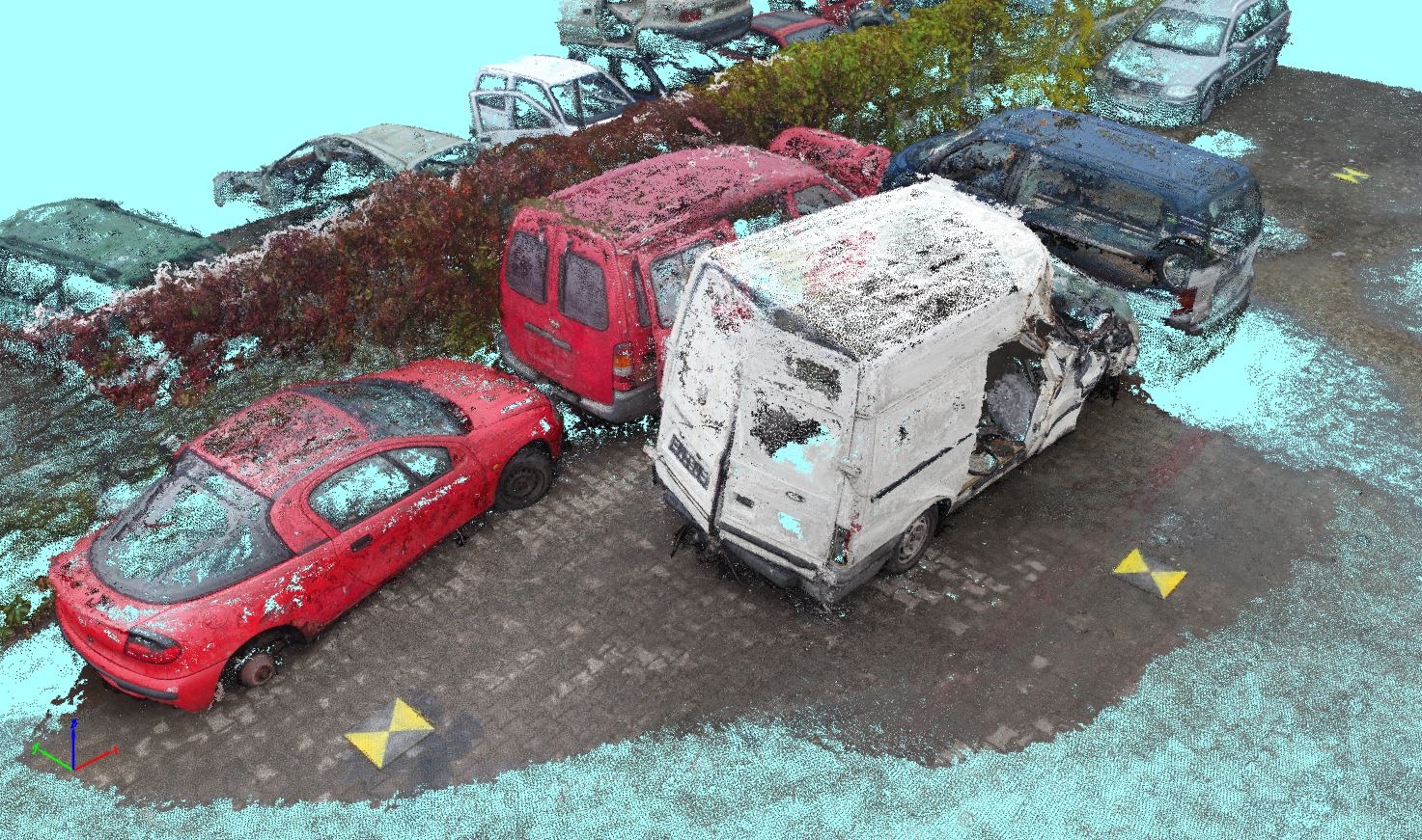
It is probably the biggest advantage of this method. Data can be gathered within 10–15 minutes, then we can restore the traffic and analyse what we obtained later. The camera placed on a drone makes photos with a spatial resolution of approx. 1 cm, so we can see really small pieces, such as glass shards or small vehicle parts.
Flying Detective
“We arrive at the scene of the accident and, considering everything that the police officers require, we specify the drone’s flight trajectory”, explains Dr Bakuła. “The camera mounted on the drone is set to make photos in specific intervals, reflecting the distance made by the drone. Thanks to photos made in appropriate intervals, we can obtain three-dimensional models of the situation”.
The photos are later linked in photo networks using special software. The software knows the place where the photo was made and, based on approximate GPS coordinates, determines its spatial position.
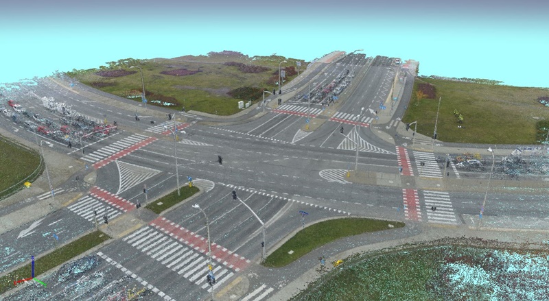
“Then we can generate the point cloud, i.e. the representation of reality using points with specific coordinates, which provides great measurement possibilities”, continues the project’s leader. “Then the computer determines point coordinates in three dimensions. This gives us a surface model onto which the photo is projected, which results in the so-called orthophotomap that allows measuring characteristic distances”.
The resultant model enables us to thoroughly analyse the site, its structure, and to reproduce the event. It can serve as technical documentation for the inspection report, and as basis for police sketches. The resulting products are a realistic reflection of reality and may influence the speed of court proceedings.
“Naturally, the drone does not fly in all conditions”, emphasises Dr Bakuła. “It’s definitely impossible to fly in strong wind and rain, at least for the time being. However, we already tested that the drone is easily capable of making photos during the night if the site is illuminated by street lights or other external light source. A small issue may be posed by trees present near the site, but everything depends on their location. The pilot’s experience is certainly crucial”.
Who Will Benefit?
Specialists from the Warsaw University of Technology offer a wide variety of services that could be used daily; however, the natural path to implementing complex products is in showing the possibilities of simpler solutions.
Since it’s a relatively cheap solution (a drone with a camera costs approx. PLN 5 thousand), its introduction is probable even for smaller units, e.g. district police headquarters. Naturally, not everyone can fly a drone. “Many qualified and open to development people work in the police force”, emphasises Dr Bakuła. “After a short training course and passing a national exam, they could easily become professional pilots. Furthermore, certain police headquarters already have drones they use to e.g. monitor large parties”.
Photogrammetric surveys of accidents made with the use of drones may be of further interest to court-appointed experts and insurance companies. Development of these techniques is mainly limited by law and... prejudice against drones. “The market should be supported with respect to the development of conscious and well-prepared methods using drones, but, most of all, we need to educate people on this subject”, summarises Dr Bakuła. “We slowly recognise this technology and see many possible uses, but there’s a lot of work ahead of us. In addition to drones used by the Police, we have a lot of other ideas that we’ll also keep trying to realise”.
Monika Bukowska
Office for Promotion and Information
© 1998-2026 Warsaw University of Technology
Pl. Politechniki 1, 00-661 Warsaw, Poland
