


HERMES project: analysing historical archival data using Artificial Intelligence
HERMES project: analysing historical archival data using Artificial Intelligence
At the Faculty of Geodesy and Cartography of Warsaw University of Technology, the project "Historical Earth Research for Multitemporal Evolution Study by Remote Sensing technique (HERMES)" is being carried out. The initiative focuses on developing a modern, fully automated method for analysing archival aerial photographs using artificial intelligence.
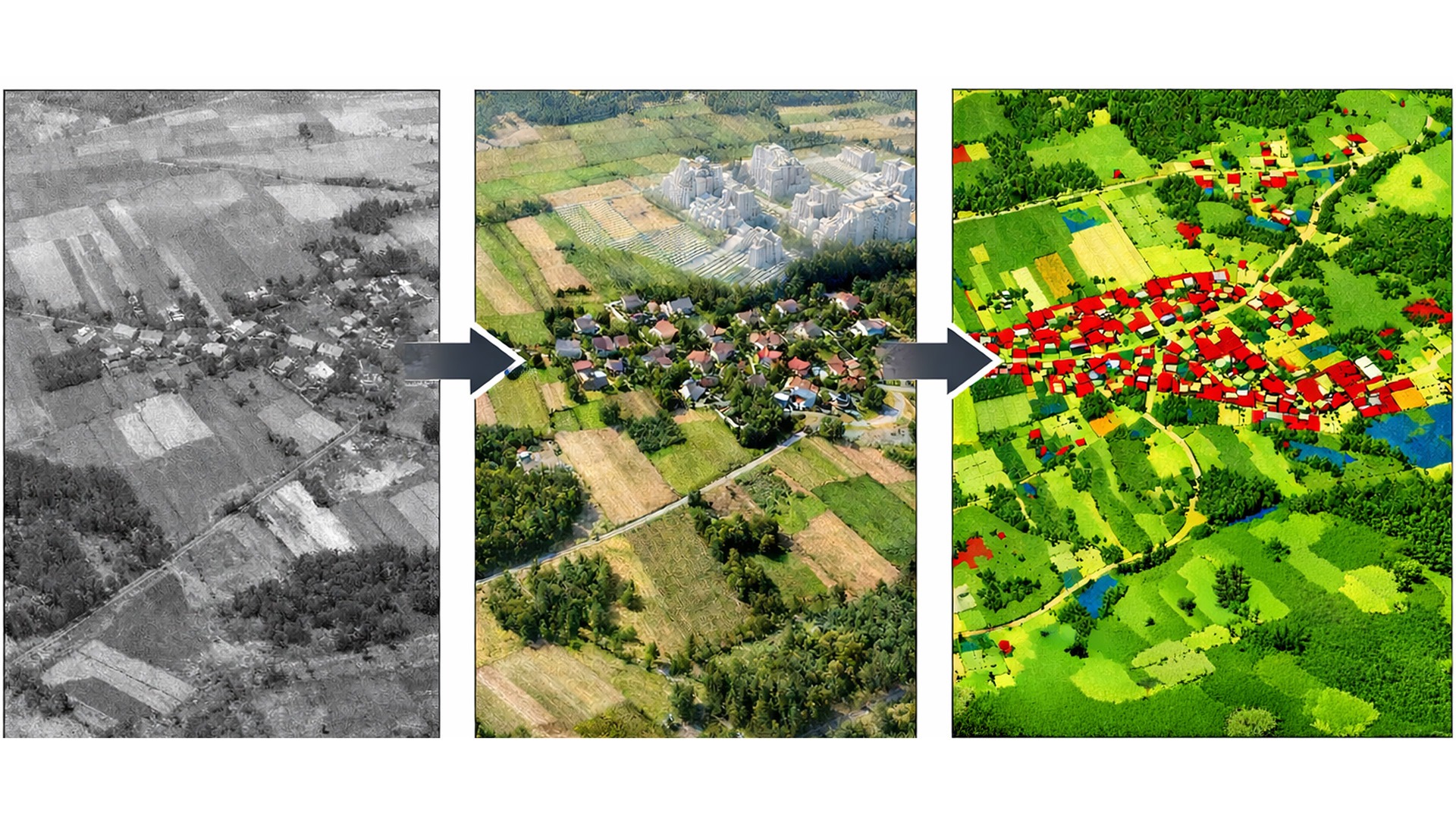
Polish geodetic archives contain approximately two million aerial photographs taken since the 1950s. These images constitute a unique record of landscape transformations – urban expansion, agricultural land-use changes, loss of natural habitats, and infrastructure development. Until now, analysing such materials has been time-consuming and largely manual. The HERMES project aims to develop a complete processing workflow: from digital processing of photographs (orientation, generation of elevation models, orthophotos), through image enhancement (colourisation, resolution improvement), to automated semantic segmentation and object detection using deep neural networks. In practical terms, the goal is to transform archival aerial photographs into fully fledged digital data sources for spatial analysis – comparable in quality and usability to modern satellite imagery.
A team redefining perspective
The project is led by Adam Kostrzewa, MSc, a PhD student at the WUT Doctoral School and an assistant at the Institute of Civil Engineering at the Warsaw University of Life Sciences (SGGW). Scientific supervision is provided by Prof. Krzysztof Bakuła, an expert in photogrammetry, remote sensing, and spatial data processing.
“I am the originator and project leader," says Adam Kostrzewa. "I am responsible for the research concept, acquisition and processing of archival data, designing deep learning experiments, training and evaluating segmentation models, as well as analysing and interpreting the results. The topic of archival aerial imagery is the core of my doctoral research at the Faculty of Geodesy and Cartography of Warsaw University of Technology. The project is a natural continuation of several years of my research and scientific publications on historical aerial image processing."
The project is scheduled for 36 months and is divided into three successive stages. The first phase (months 1–6) focuses on the acquisition and processing of data. The second phase (months 7–27) involves experiments with AI models, image colourisation, and super-resolution techniques. The final stage (months 28–36) is devoted to analysing the results and interpreting environmental changes. The project is funded under the PRELUDIUM programme of the Polish National Science Centre (NCN). With a total budget of PLN 201,300, the grant covers research activities, computational infrastructure, and data processing.
Archival photographs as a full-fledged data source
The main objective of the project is to develop and empirically validate a method for the automatic extraction of land-cover information and environmental changes from archival aerial photographs. The research focuses on applying advanced artificial intelligence tools to the analysis of historical materials that have so far rarely been treated as fully-fledged sources of spatial data. The outcome of the project will be a set of validated AI models for segmentation and object detection in historical imagery. A methodology will be developed for integrating RGB data with Digital Surface Models (DSM) to improve classification accuracy. The project will also assess the impact of data quality factors , such as noise, resolution, and lack of colour, on algorithm performance, as well as identify the types of environmental changes that can be reliably detected.
The scope of the research includes the digital processing of archival aerial photographs, encompassing camera parameter reconstruction, georeferencing, and the generation of orthophotos and elevation models. A key component of the project is the development of strategies for generating training data using modern reference databases (BDOT10k, ALS, LPIS), as well as the training and comparison of deep neural network architectures. The research is further complemented by testing the influence of colorization/colourisation and super-resolution techniques on classification quality and by interpreting spatial changes within their broader historical context.
A new dimension of spatial analysis
The project opens up entirely new possibilities in spatial data analysis. In practical terms, its implementation will accelerate analyses related to urban and infrastructure development and enable the assessment of landscape transformation dynamics over long time horizons. It will support long-term environmental monitoring and facilitate the creation of historical spatial databases for use in spatial planning and environmental studies.
The primary beneficiaries will be public administration bodies, urban planners, and spatial planning specialists. The solutions developed will also provide valuable tools for environmental protection agencies, climate and landscape researchers, and companies operating in the geoinformation sector.
The results of the project will serve as a solid foundation for further initiatives. They may be used to build comprehensive historical land-cover databases and to conduct robust evaluations of past spatial policies. Moreover, the collected data will support modelling urbanization processes and the assessment of long-term environmental changes.
From unique archives to global applications
The Polish aerial photograph archive is one of the largest collections of its kind in Europe, which gives the project a uniquely strong and extensive empirical foundation. HERMES represents an innovative fusion of classical photogrammetry and cutting-edge AI techniques. Importantly, the developed methodology has strong potential for scalability, opening the possibility of implementation in other countries and across other historical archives in the future.
© 1998-2026 Warsaw University of Technology
Pl. Politechniki 1, 00-661 Warsaw, Poland
